Yes it is Saturday evening and we are finally home. Today was a marathon driving day - 11 hours and 682 miles. We had a very enjoyable 2 weeks. Spent time with friends, saw some beautiful scenery and enjoyed learning a bit of the history of the South and Southwest.
We had almost perfect weather - except for the first day in Cape May when we had some rain, the rest of time we had blue skies and even some 90+ temps in Alabama and Mississippi.
We spent some time in 16 states - of course that brings us to the final exam: Name all 16 states.
Harriet now has visited 48 states - she needs TX and OR. Mike has 49 - needs AK. Anybody want to guess where we are going next?
FYI - we drove 4,461 miles and are beginning to think we need to slow down a bit.
See you for the next trip.
The 16 states are: NY, NJ, DE, MD, WV, VA, TN, GA, AL, MS, LA, AR, OK, MO, KY, PA
Saturday, October 16, 2010
HAPPY ANNIVERSARY TO US
So how much more romantic could we be than to take a lovely trip as a second honeymoon (on our 38th).
Where could we possibly go to replicate the romance and beauty of Guadaloupe. Where else but Poplar Bluff, MO. We started the day in the fabulous Holiday Inn - a fabulous resort (for Poplar Bluff).
After a day of driving through Missouri, Kentucky and West Virginia (actually extremely scenic) we had a late dinner at our favorite restaurant in Charleston, WV (yes we really have one - The Tidewater Grill).
And to complete our romantic day - early to sleep so we could get up early and do some more driving.
Definitely an anniversary to remember. Actually, probably more memorable than some of the preceding 37.
Wednesday, October 13, 2010
DID YOU SAY POPLAR BLUFF?
Yes Poplar Bluff. It is a lovely little town in southeast Missouri (but we assumed you knew that). We are here for the same reason we stopped in Wytheville, Va. If you can't remember, check back to the 5 state, 500 mile blog. We got here by driving through the Ozarks. We had some wonderful scenery including three "springs", all of which are along the Current River.
 Springs are just what you would think - water bubbling out of the ground into a pool of water. But these are top of the line. Alley Springs has a lovely green color and was used as hydropower for a mill. Even though there is no geyser or rush, the spring produces over 80 million gallons of water a day.
 The next spring was at the end of a 2 1/2 mile unpaved rutted road - you all how well Harriet handled that piece of land. Then we walked through thr forest for about 1/2 mile to Blue Spring. It was worth it - an incredible deep blue pool that is so clear you can see down seemingly forever. It is actually over 300 feet deep and generates almost 90 million gallons of water a day (the surface of the pool is dead calm - only at the outlet is there the indication of rushing water).
 The rocks in the water are not a reflection. The water is so clear you can see the rocks below the water line.
Finally, we got to Big Spring - so named because it is Big - generates almost 250 million gallons a day. This one has the water coming out of the side of a hill as a gentle stream, again until about 10-15 feet further along it turns into a rushing, gushing stream.
 An attempt was made at a video:
Definitely one of our better days.
WHERE ARE WE??
You left us in Russellville, AR which is 88 miles south of our next destination. Today wasn't bad we only drove 153 miles to get here. This included a lovely drive along the Grand Canyon of the Buffalo River in Arkansas. It was actually quite beautiful even if it was hardly a canyon, more like a small wooded valley.


 Also looks a great deal like the Smoky Mountains.
If you remember this is the 2nd 'grand canyon' we have encountered this trip (seems like all the states/rivers want a piece of the action). However we did stop in a small gift shop on the rim and this store had the best selection of bells Harriet has ever encountered - she restrained herself and only got 2. We also stocked up on our favorite jellies which are actually made about 25 miles away. So it was a serendipitous stop. After arriving at our final destination, we realized we had missed the community of Eureka Springs (supposedly a quaint victorian village), AR. So back into the car for another 2 1/2 hours and 115 miles. Eureka Springs turned to be a lovely southwest tourist trap - oh well. For our grandson - the train depot in town.
 However, on the way we drove past Lake Taneycomo - one of the best things about our current location.

So where are we now?
It is Las Vegas without the casinos. It is Myrtle Beach without the ocean. It is Pigeon Forge without Dollywood. Yes blog fans, we are in BRANSON, MO.
Everything you have heard about, read about or seen about this town is true. It is 'drek' run wild. If it can be in bad taste, it lives here. But of course that is our elitist northeast view - the folks from this neck of the woods (everywhere within about 1000 miles east, south and west) think it is the greatest thing since sliced white bread (suffice to say we have kept our opinions to ourselves). It was so 'drekful' that Harriet refused to take any pictures.

 Also looks a great deal like the Smoky Mountains.
If you remember this is the 2nd 'grand canyon' we have encountered this trip (seems like all the states/rivers want a piece of the action). However we did stop in a small gift shop on the rim and this store had the best selection of bells Harriet has ever encountered - she restrained herself and only got 2. We also stocked up on our favorite jellies which are actually made about 25 miles away. So it was a serendipitous stop. After arriving at our final destination, we realized we had missed the community of Eureka Springs (supposedly a quaint victorian village), AR. So back into the car for another 2 1/2 hours and 115 miles. Eureka Springs turned to be a lovely southwest tourist trap - oh well. For our grandson - the train depot in town.
 However, on the way we drove past Lake Taneycomo - one of the best things about our current location.
So where are we now?
It is Las Vegas without the casinos. It is Myrtle Beach without the ocean. It is Pigeon Forge without Dollywood. Yes blog fans, we are in BRANSON, MO.
Everything you have heard about, read about or seen about this town is true. It is 'drek' run wild. If it can be in bad taste, it lives here. But of course that is our elitist northeast view - the folks from this neck of the woods (everywhere within about 1000 miles east, south and west) think it is the greatest thing since sliced white bread (suffice to say we have kept our opinions to ourselves). It was so 'drekful' that Harriet refused to take any pictures.
Tuesday, October 12, 2010
Arkansas Travellers/O-K-L-A-H-O-M-A, OK
Okay loyal blog followers, you all remember that yesterday we left you in Little Rock knowing that today we were going to tour other parts of Arkansas. We started by going to Hot Springs Nat'l Park which is unique in that the park is in the city proper and has almost no scenic drives.However we managed to find the one drive before doing anything else. A view of Hot Springs from above:
 The entire area reminded us of Saratoga Springs - shops and older preserved buildings in the foothills of the mountains. But walking down the main drag you have a line of luxury baths,
 one of which functions as the park visitor center and allows a tour of the facility - it must have been nice to have the bucks to take advantage of 'the baths' and other amenities.

 We then started on the scenic drive through the hills of Arkansas. It was very pretty and very quiet. When we got to the western end of the tour, rather then heading north, we checked the the time and mileage and we went WEST. This minor 2 hour detour enabled Harriet to set foot in OKLAHOMA - state 48 - yay. We cross the Arkansas River heading into Oklahoma.
 Anyway after 300 miles of driving we wound up in Russellville, AR which is about 85 miles from Little Rock (another normal day in tour Malinak).
 The entire area reminded us of Saratoga Springs - shops and older preserved buildings in the foothills of the mountains. But walking down the main drag you have a line of luxury baths,
 one of which functions as the park visitor center and allows a tour of the facility - it must have been nice to have the bucks to take advantage of 'the baths' and other amenities.
 We then started on the scenic drive through the hills of Arkansas. It was very pretty and very quiet. When we got to the western end of the tour, rather then heading north, we checked the the time and mileage and we went WEST. This minor 2 hour detour enabled Harriet to set foot in OKLAHOMA - state 48 - yay. We cross the Arkansas River heading into Oklahoma.
 Anyway after 300 miles of driving we wound up in Russellville, AR which is about 85 miles from Little Rock (another normal day in tour Malinak).
Heading North
Monday was a different day. Originally we were going to take a circuitous route from Vicksburg to Little Rock to enable Harriet to set foot in some states she had never been in. Fortunately/Unfortunately when we checked the weather before starting out, we saw that there was a nasty patch of weather right where we were going. A quick change of plans sent us slightly west into Louisiana to the site of an ancient civilization called Poverty Point (1800B.C.). Very unique. The original inhabitants built their 'homes' on man made ridges (about 6 feet high), to protect them when the bayous flooded. There were 6 semi cicular sets of ridges, each one getting longer the further ut from the center, where there was a community gathering spot. In addition, there were several man made mounds, one of which was almost 100 feet high and when viewed from the air looks like a bird. It was hard to get any pictures that clearly showed what we saw (especially since during the 1800's the land had been extensively farmed (poorly because that was how it got the name Poverty Point). Here are a couple of attempts:

 We then turned North and got to Little Rock in time to check out the city, including the capitol building
 and statues along the river.

 and see "The Little Rock".
 We did not take pictures of the Clinton Library which is a little ways up thr river. It looks like an enormous double wide - very uninspiring, but very Arkansas.
Health alert - Little Rock permits smoking in restaurants. The first one we tried allowed smoking - we left. Finally wound up in a TGI Fridays.
Harriet did manage to add Arkansas as state 47. Tomorrow we expect to stay in Arkansas all day (how dull).

 We then turned North and got to Little Rock in time to check out the city, including the capitol building
 and statues along the river.
 and see "The Little Rock".
 We did not take pictures of the Clinton Library which is a little ways up thr river. It looks like an enormous double wide - very uninspiring, but very Arkansas.
Health alert - Little Rock permits smoking in restaurants. The first one we tried allowed smoking - we left. Finally wound up in a TGI Fridays.
Harriet did manage to add Arkansas as state 47. Tomorrow we expect to stay in Arkansas all day (how dull).
Sunday, October 10, 2010
Natchez Natch
Today was another day of mostly history, plus interesting old 'houses' (mansions) and some nice scenery. We drove down to Natchez on US61 - a most uninspiring road (of course since the land is basically flat couldn't expect much). Natchez is an historical town and we spent 2-3 hours on our own driving tour. Saw the historical buildings and the very large mansions. However, for some reason we thought the mansions were all right along the river - none of them were. Here are some examples:


Along the river
 was a section called "Under the Hill". It was the Barbery Coast of Natchez; home to bars and other bawdy type places back in the 1800s - now it is a place for tourists.
 We then headed north on the Natchez Trace Parkway. The Natchez Trace was a trail that ran from Natchez to Nashville (440 miles) and was used for hundreds of years by traders, slaves, native american, etc. Harriet on the Trace:
 It was heavily used by farmers from the Tennessee valley. They would float their crops down the river to Natchez where they would sell everythng including their boat/raft and then walk back to Nashville via the Trace. There are places where the trail was worn down 15-20 feet below the surrounding countryside.
 Back in Vicksburg, we took a short driving tour of some of the interesting spots in town ending up down at the river where there is a series of murals stretching about 200 yards depicting the history of Vicksburg. Once we publish the pictures to Shutterfly (hopefully this decade) - readers will be able to see many of the scenes.
 We went to a riverboat casino for a buffet dinner - reasonable food on the cheap. Best thing was we got there just in time for sunset over the river.
 Seems hard to believe but we never left Mississippi -all day in one state - seems impossible, but wait for tomorrow.
Saturday, October 9, 2010
So Far So Good
Today was good! No lost earrings; no forgotten hatches; no wasted tours. Easy drive from Birmingham to Vicksburg. Speaking of Birmingham - ate at a really good old fashioned BBQ joint. Once we arrived in Vicksburg arrived at our Motel a bit early, but the Manager checked us in (he was more than a bit uncertain about the computer system and we had to wait and wound up in a 'handicapped' room with 2 doubles instead of the king room we had reserved). Went down to request a change and he not only changed the room, but put us in a room with a fridge w/freezer and a sink and a full sized couch. Yay us!
Then, did not get lost going to the Vicksburg Battle site. Spent 2-3 hours driving through the site. Very informative and got a much better understanding about how the battle/siege took place. The battle siege lasted 47 days, during which time the Union forces constantly shelled the city leaving mostly rubble.
Then, did not get lost going to the Vicksburg Battle site. Spent 2-3 hours driving through the site. Very informative and got a much better understanding about how the battle/siege took place. The battle siege lasted 47 days, during which time the Union forces constantly shelled the city leaving mostly rubble.
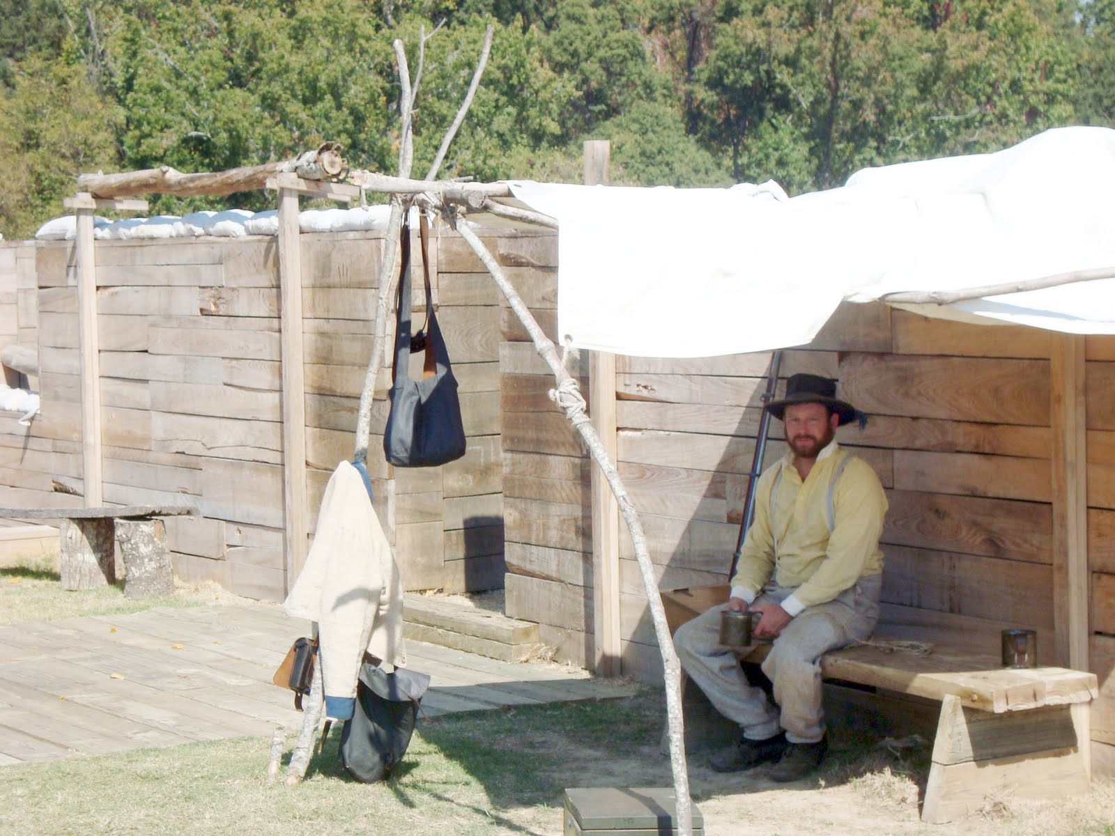
A confederate soldier behind the fortifications.
 Each of the states that had men at the battle put up monuments to remember the participants. The largest is Illinois - actually lists every soldier from Illinois who was at the battle.
 Each confederate state also had a monument - chose Texas just because it was rather 'attractive'.
 We forget that part of the battle was fought on the rivers (Mississippi and Yazoo). A union Ironclad - the USS Cairo (pronounced Care-o) was sunk by mines, and was later salvaged and re-built using as much of the original materials as could be dredged.
Tonight ate at a local 'grille' downtown near the river. Not great, but good local color.
Quiz: What river was the 'grille' near? Remember, no using an atlas or other aid.
10/30 - this is a trick question. Everyone knows that Vicksburg is on the Mississippi. Whoops - it was during the Civil War, but during the 1870's and 1880's the river cut a new channel which left Vicksburg high and dry (the river comes back just south of town. During the 1930's a canal was dug connecting the Yazoo north of the city with the Mississippi south of the city - so the correct answer was Yazoo Canal.
Tomorrow, we do some of the Natchez Trace Trail and then back downtown for some picture ops. This being the 'deep south', nothing is open for dinner tomorrow. However, when we checked at the front desk we found out that one of the riverboat casinos has a buffet and of course the casinos don't close.
FYI - yesterday, Harriet made it to state 45 in Alabama; today, Mississippi was state 46; today Mike made it to state 49.
Friday, October 8, 2010
A Lost/Forgotten Day
Today was supposed to be an easy day, less than 300 miles following a route from the tour book we have used for years. The morning started with Harriet losing a backing from an earring which left her with a couple of open holes in her earlobes. Luckily she stepped on it just before we left and all was good. We loaded the car and off we went - about 150 feet before another car honked at us - oops Mike had forgotten to lower the hatchback - luckily nothing fell out. Since we don't believe in omens we decided to try to find a couple of scenic sites north of Chattanooga. First was Signal Mountain - turns out that Signal Mountain is the name of a bedroom community of Chattanooga located on a mountain - if there was a scenic view we never found it. However, we did locate a gas station which gave us a full tank for the day - stay tuned.
We then tried to find "The Grand Canyon of the Tennessee River. Turns out that the only way to it is by boat - oops, another 20 miles lost. Ah well, it would get better (or not). Did get a picture of the river:

Then we head south to famous Lookout Mountain (which is actually in three states - TN, GA, and AL). Turns out everything on the mountain has to be paid for. To get to the high point for a good look, you first have to pay $16.95 to ride down an elevator to a set of caverns and an underground waterfall - we passed and then wandered around various roads trying to find a park that also had an overlook - probably did, but to get to it - had to pay another $16.95 to go through a Civil War battle site - no chance. We did find a place to get a shot from the mountain:
 By now we were officially lost, but by sheer grit and dumb luck fell onto the road we needed to continue south. Yay! (or not)
We then tried to find "The Grand Canyon of the Tennessee River. Turns out that the only way to it is by boat - oops, another 20 miles lost. Ah well, it would get better (or not). Did get a picture of the river:

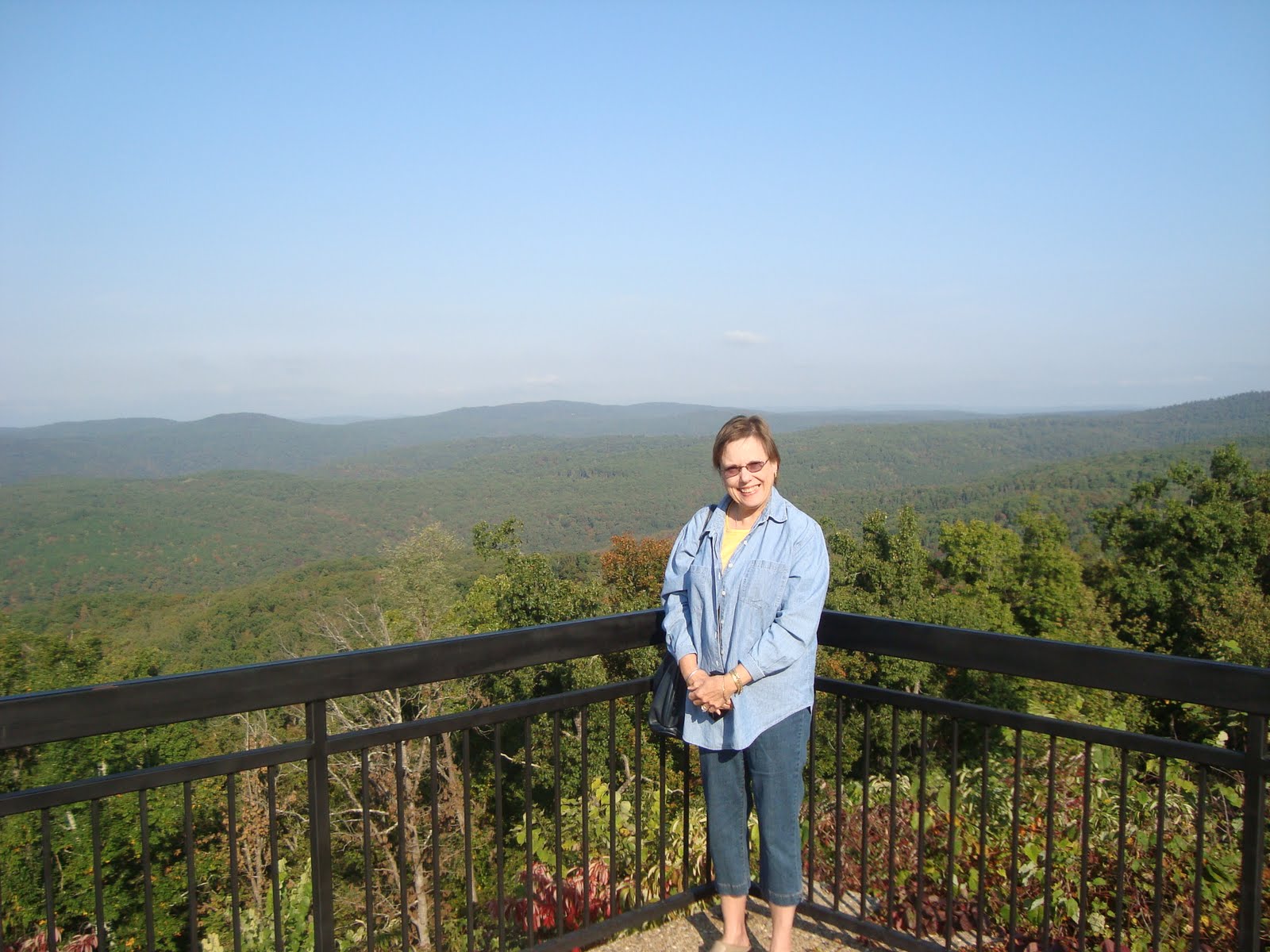
Then we head south to famous Lookout Mountain (which is actually in three states - TN, GA, and AL). Turns out everything on the mountain has to be paid for. To get to the high point for a good look, you first have to pay $16.95 to ride down an elevator to a set of caverns and an underground waterfall - we passed and then wandered around various roads trying to find a park that also had an overlook - probably did, but to get to it - had to pay another $16.95 to go through a Civil War battle site - no chance. We did find a place to get a shot from the mountain:
 By now we were officially lost, but by sheer grit and dumb luck fell onto the road we needed to continue south. Yay! (or not)
 10/30 - by now it was time for lunch and a pit stop. Unfortunately there was nothing on these back roads so we paid $5.00 to get into a state park to take care of business. It was actually a pretty good spot for a picnic lunch.
 Rather than bore you further with our trials and tribulations, suffice to say we found waterfalls with no water, waterfalls that you had to pay to see, waterfalls that required a 2 hour up and down (1200 steps) to see - guess what? we were not overjoyed (and wound up actually viewing the one waterfall which had less water falling than your average leaky faucet) especially since the signage in this part of the country is designed to ensure you have no idea which way to turn or where any 'attractions' are located.
By best estimate we drove an extra 85-100 miles to see nothing. Can't wait for tomorrow.
After this fine day, we have decided to cancel today's quiz.
Thursday, October 7, 2010
CHOO CHOO
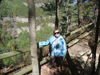
Today was supposed to be a straightforward run from Wytheville, VA to Chattanooga, TN - interstate highways all the way - about 300 miles. So we made a pit stop at the Tennessee welcome center and picked up some brochures. One was for The Cherohala Skyway. Looked like a combination of the Blue Ridge Parkway and Great Smoky Nat'l Park. As the start of the Skyway was about 20 miles from the interstate at Tellico Plains, we made a detour. The Skyway is actually in The Cherokee Nat'l Forest. The first 6-7 miles is a 2 lane winding road with guard rails running right along the Tellico River. The next 8-9 miles the road is about 1 1/2 lanes wide, still along the river and stll winding, but with no guardrails.

At the end of the road are the Bald River Falls (about 100 feet high and pretty nice). Our guide was pretty and nice!
 Today's quiz is a multiple choice:
What color was Harriet during the 16- or so miles on the narrow, guardrail free portion of the road?
a) white as a sheet
b) off (very off) white
c) ashen grey
d) pretty pink
The correct answer was D! Harriet was fine because we weren't climbing straight up and there were no real hairpin curves.
Anyway, we made it to Chattanooga and had dinner downtown near the Tennessee River and The Chattanooga Choo Choo. Yes, there is a Chattanooga Choo Choo - it sits on top of the building.

It is actually a luxury hotel in the old Chattanooga train station. Old railway cars are also available as suites.
 Sounds like great fun, but too rich for our blood.
Tomorrow we head to Birmingham, AL via Lookout Mountain Parkway with other detours possible.
Pictures and quiz answer added 10/30.
Subscribe to:
Posts (Atom)